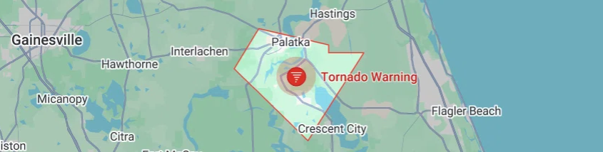
A tornado warning that briefly swept across northeastern Flagler County on Thursday prompted a shelter-in-place order at Flagler County Schools and sent residents scrambling for safety as rotating thunderstorms tracked across Palm Coast and Bunnell. The warning — driven by radar-indicated rotation and a severe thunderstorm capable of producing a tornado — expired later in the afternoon. Still, forecasters warned that dangerous storms and strong gusts would continue into the evening.
Local officials said the tornado warning triggered immediate protective actions at school campuses: Flagler County Schools announced that buildings would shelter in place and that dismissal for students still on campus could be delayed while officials monitored conditions and notified families directly via text, phone, and email. The district advised families to wait for official communication before attempting to pick up their students.
What happened (timeline & radar details)
At about 2:28 p.m. EDT, the National Weather Service and local weather trackers reported a severe thunderstorm capable of producing a tornado located over Palm Coast, moving east at roughly 10 mph — prompting the tornado warning and urgent weather messaging for northeastern Flagler County. Radar showed rotation within the storm cell, which is the primary indicator meteorologists use to issue tornado warnings. Officials emphasized that radar-indicated rotation can spin up brief, dangerous tornadoes, and that anyone in the storm’s path should seek sturdy shelter immediately.
The tornado warning that covered Flagler County was listed as expired after officials determined the most immediate threat had passed; nonetheless, meteorologists continued to forecast additional storms across the region with the potential for damaging winds, heavy rain, and localized tornadoes through the evening hours. Local forecasts and broadcasters advised residents to monitor alerts and expect intermittent severe weather through about 8:00 p.m.
Also visit:-
Festival of Nations MN 2026: Minimalist Schedule + Ticket Tracker
Solar Storm Warning: Cannibal CME Targets Earth With Aurora Potential Over Labor Day 2025
Social media alerts and live updates
In real time, residents posted warnings and photos on social media as the storm moved through the county. The following tweets (copied here verbatim, as requested) circulated among local users and emergency monitoring feeds:
“# tornadowarning for northeastern Flagler County in northeastern Florida until 3:00p Edp for a severe thunderstorm capable of producing a tornado located over Palm Coast, or near Bunnell, moving east at 10 mph.”
“Severe T- T-T-storm warning has been issued for Putnam until aug 28, 3:30 pm. If you are in the path of this storm , seek shelter now! “
Those posts mirror the urgent tone of official alerts and underscore how quickly information — and concern — spread across platforms as the storm unfolded. (Readers should note that social posts often contain typos and approximate times; official warning times and texts from the National Weather Service and county emergency management remain the authoritative sources.)
Impacts: roads, visibility, and local operations
Local traffic and weather outlets reported that visibility dropped in some areas due to heavy rain and that wind-driven debris and downed limbs were possible. Reports of hail and strong gusts accompanied the storm in parts of Flagler County, and some road travel advisories urged drivers to slow down or avoid nonessential travel while the system passed.
Emergency managers encouraged residents to secure outdoor items, stay away from windows, and avoid driving through flooded or debris-covered roadways.
Schools and shelters
Flagler County Schools followed pre-established emergency protocols by sheltering students and staff in secure interior spaces while monitoring the situation. The district’s emergency notifications system sent direct messages to families and staff; officials reiterated that schools are designated as shelters in certain emergencies and the district will only release students once conditions are deemed safe. For residents seeking shelter information, County Emergency Management and the Flagler Schools website guide designated shelters and procedures during severe weather events.
Forecast and safety guidance
Meteorologists urged residents to remain weather-aware throughout the evening as additional storm cells — some capable of producing damaging winds and localized tornadoes — moved through northeast Florida. The National Weather Service’s Jacksonville office and local broadcasters encouraged people to:
- Move to an interior, windowless room on the lowest floor if a tornado warning is issued for your area.
- Avoid driving during heavy rain and low visibility; do not attempt to drive through flooded roads.
- Keep an emergency kit (water, flashlight, radio, medications) accessible and a NOAA weather radio or reliable alerts active on your phone.
What residents should watch for next
Although the immediate tornado warning in Flagler County expired, scattered to numerous thunderstorms were expected to continue, with the potential for strong winds, localized flooding, and additional severe thunderstorm or tornado warnings. Residents are advised to:
- Keep monitoring official NWS updates and AlertFlagler emergency notifications.
- Follow guidance from Flagler County Schools if you have children on campus — do not attempt to pick up students until the school communicates that dismissals have resumed safely.
Local response & community reaction
Community responders and county emergency management teams remained on heightened alert, coordinating with school officials, law enforcement, and public works to respond to any storm damage, blocked roads, or power outages. Local news crews captured live radar imagery and on-the-ground reporting as residents in Palm Coast and Bunnell sought shelter. Many residents posted images of heavy rain, downed branches, and intermittent power disruptions on social media, emphasizing the need to prepare for after-effects such as debris removal and localized flooding.
Bottom line: take current watches seriously
Today’s tornado warning in Flagler County highlighted how rapidly severe weather can escalate in northeast Florida. Even after a warning expires, the risk from additional thunderstorms remains real — and conditions can change quickly. Authorities emphasize that the safest course of action during radar-indicated tornado warnings is to seek interior shelter immediately and to follow local emergency messaging until officials confirm it is safe to resume normal activities.
Tropical Storms in the Atlantic — Why the Calm Could Fuel a Fierce Finish
1 thought on “Flagler County Tornado Warning: Palm Coast Storm Sparks Shelter-in-Place, More Severe Weather Expected”